Goals and Objectives
By the end of
the lesson, students will understand the diverse physical landscape of Vietnam.
Students will be able to locate Vietnam on a map of the world, identify the
major geographic features of Vietnam, and explain how the geographic features
impact the population distribution of the country.
Content Standards
6.6 Students analyze the geographic, political, economic, religious, and social structures of the early civilizations of China.
Lesson Introduction
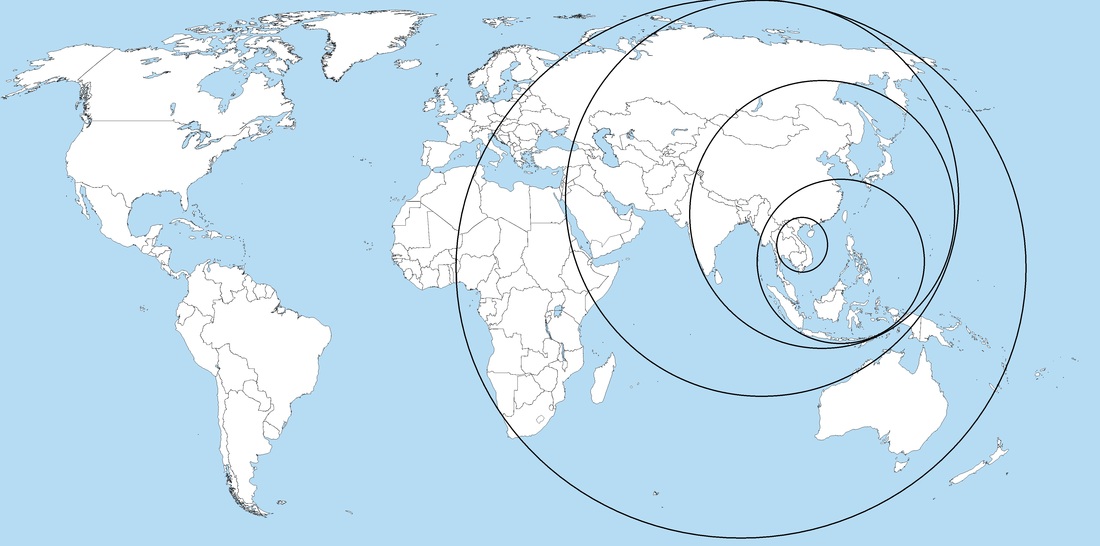
Interaction Strategy (Nesting Circles) – Give each student a map of the world. Direct them to circle the following regions/places in order. This activity helps students to situate Vietnam in the larger region and world, and enables students to recognize geographic locations from more well-known to less well-known.
Eastern hemisphere
Asia
East Asia
Southeast Asia
Vietnam
Eastern hemisphere
Asia
East Asia
Southeast Asia
Vietnam
Vocabulary
Presentation Strategy (Bulletin Board) - Geographic terms
will be discussed prior to the rest of the lesson as students will need this
knowledge to complete the student engagement activity. Students will be given a
list of new terms (below) and will be directed to complete a digital poster
showing pictorial examples of the new terms. If computers are available,
students can work in pairs to complete the poster. If not, the class can
complete the activity as a whole with the teacher using an LCD projector to
display the digital poster to the class. The teacher will search for images of
the terms, have the class choose the best examples, and then insert them on the
digital poster. An example poster is below. The key terms for the lesson include:
alluvial fan
silt
delta
plateau
terraced fields
alluvial fan
silt
delta
plateau
terraced fields
Content Delivery
Presentation Strategy (Interactive Lecture) - The teacher will show a prezi presentation on the geographic features of Vietnam. The presentation progresses through a series of questions which ask students to find specific geographic features of Vietnam. The students use the context cues in the questions to locate the feature on the map. As students identify each geographic feature, the teacher zooms in on the feature in the prezi presentation.
Student Engagement
Organization Strategy (Guided Notes) - During the lecture presentation, students will have guided notes which they will complete as the lecture progresses. The guided notes consist of a map of Vietnam with major geographic features identified and space available for notes. As the teacher asks students to find these features during the presentation, students will write important pieces of information in the space provided.
Lesson Closure
Communication Strategy (Quickwrite) - Vietnam is often
described as “two baskets of rice separated by a bamboo pole.” In pairs, have
students discuss what they think this means (hint: where in Vietnam is most of
the rice grown, and what separates these two regions?). Once they come to a conclusion have them write
a summary paragraph on their guided notes explaining where the majority of the
population lives in Vietnam and why.
Assessment
Entry-Level – At
the beginning of the lesson, the teacher will check student’s concentric maps
to see if they properly identified the geographic regions in which Vietnam is
located.
Formative - During the presentation the teacher will check to see if the students have identified the correct geographic features by walking around the room and checking their guided notes throughout the presentation.
Summative - At the end of the lesson, students will write about how the geographic features of Vietnam impact the population distribution.
Lesson Resources
Books
Weightman, B. (2011). Dragons and Tigers: A Geography of South, East and Southeast Asia, 3rd ed. Hoboken, NJ; John Wiley and Sons, Inc.
Websites
Geographia: Vietnam
Country Studies: Vietnam Geography
Atlas of Vietnam
Interactives
MapMaker Interactive
Weightman, B. (2011). Dragons and Tigers: A Geography of South, East and Southeast Asia, 3rd ed. Hoboken, NJ; John Wiley and Sons, Inc.
Websites
Geographia: Vietnam
Country Studies: Vietnam Geography
Atlas of Vietnam
Interactives
MapMaker Interactive